|
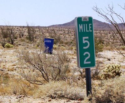
Royal blue 55 gallon drum container marked "AGUA" that holds
many factory sealed one gallon plastic containers filled with
water from the Borrego Springs Water Company, Southern
California. Photo Credit: Edmund Jenks (2006)
|
S2 & The Mile Marker Mystery Tour
Is the photo above evidence that would suggest the potential existence of a
California State sponsored “underground railroad”, facilitating the movement
of illegal immigrants northward, on this road east of San Diego,
California?
Read the whole story below and help me to find
out.
On Friday, June 9th, 2006, I had occasion to attend a business seminar and new
product introduction at the W Hotel in downtown San Diego. After spending a
lovely evening in Old Town San Diego, it was decided the next morning to take
the long way home back to Los Angeles.
We looked at a map after reading about the history of how Southern California
built its communicative and travel infrastructure on the routes of the
Great Southern Overland Stage Route of 1849 and the old Butterfield Overland
Mail stages. So we set out east on Highway 8 before heading north, tracking along a line
on the map that started at Ocotillo (a settlement about 2.5 miles due north of
our border with Mexico), through the little town of Agua Caliente on San Diego
County "S2".
S2,
as shown on the map, is a road that goes mostly through Anza-Borrego Desert State Park in the
south, and ends near Warner Springs at California State Highway 79 in the
north.
Late morning, upon entering the Park, about 3 miles or so north from Ocotillo,
we saw the Border Patrol and a few National Guard troops setting up an
immigration check point along the road. We thought to ourselves, "Well, so this
is evidence of the new program of joint deployment we had heard about recently
in the news", and then turned our attention to the beautiful landscapes that the
far southern parts of the California deserts have to offer.
Driving along another couple of miles or so, we crested a rise in the road and
my wife exclaimed, "Did you see that?"
"See what?" I asked.
"Did you see that blue can ... or thing along side of the road? It said "Agua"
on side of it!" Cookie exclaimed.
"What do you mean?" I asked.
"It was more of a large drum, and it had stenciled along the side in white
lettering "AGUA", you know, Spanish for water.” she said.
We drove on and noticed in the next minute and a half another blue drum, but
this one had "AGUA" along the top with "WATER" stenciled in white just
underneath along the side.
I asked, "What is going on?"
Another 90 seconds or so passed and another blue drum sat along the side of the
road.
Questions arose and the mystery began to build. Where did these blue drums come
from? Why are they here? Who put them here? Why are most of them identified only
in Spanish?
"Hey, Cookie, let's stop and look at the next one we see, okay?” I asked. She
responded, "I think that they are placed near the mile markers along the side of
the road."
And sure enough, at mile marker 52, there was another large blue drum (photo
above).
I stopped the car, got out and walked across the street over to the west side of
S2, and in from the mile marker a few feet I arrived at the side of the blue
drum, camera in hand.
The drum was topped off with a half-disk shaped wood top that appeared to have
been designed to keep the sun from reaching the contents inside. As I peeked
into the drum, the shade in the bottom of the drum covered 6 containers holding
a gallon of water each.
I reached down into the drum and pulled out one of the gallon containers to
inspect it. The container was factory sealed and labeled as being produced by
the
Borrego Springs Water Company, complete with UPC barcode, ready for retail
sale.
More questions rushed forward in our minds. Who is paying for this? Who is
keeping the "water stations" stocked and maintained? Isn't this State of
California land? This is a road that runs through a State Park after all! How
does one get permission to do something like this ... that is, if it isn't the
State of California that is doing the duty? Is the National Guard responsible
for these support services too?
We drove on and discovered that not only are these blue drum "AGUA" water
stations at each mile marker, one appeared in a dry streambed that was an
obvious migrant trail track also used for hiking and offroading.
We drove on from the South to the North and it appeared that the blue "AGUA"
drums were placed at every mile marker from mile marker 55 to mile marker 40
near the Agua Caliente airport. Beyond mile marker 40 on northward, no more
drums were sighted. We drove throughout the park that entire day without
sighting anymore blue drums for park visitors or anyone else … other than in the
most southerly 15 mile section along this road, as described. Curious that.
This situation is a real mystery. When almost 70% of the voting citizens want to
put up a fence, and implement processes that deter border hopping immigration,
why is the State of California subsidizing, underwriting, working against,
turning a blind eye to, anything that will facilitate illegal immigrants to
migrate across the border, hide and survive just to assimilate into our
capitalistic landscape?
So now it is time for
MAXINE (maxine-log.blogspot.com) to turn to the internet
community and, hopefully, tap into the power of, as Glenn Reynolds at
Instapundit and MSNBC would put it, "An Army of Davids"!
Are there any answers out there to the questions raised by this mile marker
mystery tour?
Further, I have photos and digital video clips to support this whole story if
any one would need them to help spread the story and/or make the point. I look
forward to your responses. "On point".
UPDATE - May 5, 2025 -
nearly nineteen years later on Cinco de Mayo:
The problem of open borders has finally come to an end in just 60 days after the election of #DJT47 (formally #DJT45). Discoveries on just how much Federal Government support has been applied to this orchestrated invasion of our country by the Democrat Political Party leadership shows itself with FEMA boxes of food supplies being found at stations along the Southern Border, FEMA was used by Alejandro Nicolas Mayorkas - the American attorney and government official who was the seventh United States secretary of homeland security, serving from 2021 until 2025 - as an underwriting agency to aid in the unbridled/unvetted flow on non-citizen Foreign Nationals into the United States through an Open Borders set of policies. A treasonous act that rendered our crafted immigration laws useless through intentional activity and taxpayer monetary support.
Text of the following FB/META exhibit >>> Border Patrol uncovered thousands of FEMA relief packages scattered in storage locations along the southern border, put there by the Biden administration to feed illegals as they crossed.
The packages were rerouted in 2024 from Tennessee, Georgia, and North Carolina after Hurricane Helene.
America's Last Line Of Defense - We've traced the source of this story to a pair of teenagers in Texas who purchased those fake "Border Patrol" windbreakers on Amazon so they could stand in front of Home Depot to scare away Mexicans. "We've caught up with the boys and learned that they took the FEMA packages without permission," said Arkansas Attorney General Joe Barron, "Then they put them in Yeti coolers they collected from conservative trash cans back in 2019 and spread them out across the border to make it look like Biden was feeding the illegals." Barron said the boys won't be prosecuted because ultimately, they meant to hurt Joe Biden and the libs, which qualifies them for amnesty in 13 states now. Thank God for kids like these. Did we mention that at 17 years old, each of them has an AR-15 collection that would rival a small police department? Well done, parents!
ENDS
 Brewed Awakenings, with its pithy name, artful drinks and wireless Internet service, has found itself unexpectedly percolating on the forefront of high-tech law. Image Credit: KATU - Channel 2, Portland


